For municipalities, district councils and agricultural agencies
Every vineyard in the commune, measured row by row
Solemtrix turns drone imagery into the complete map of the plantations: blocks, rows, every plant, gaps and waste. And the team gets inspection tasks with a ready-to-walk route.
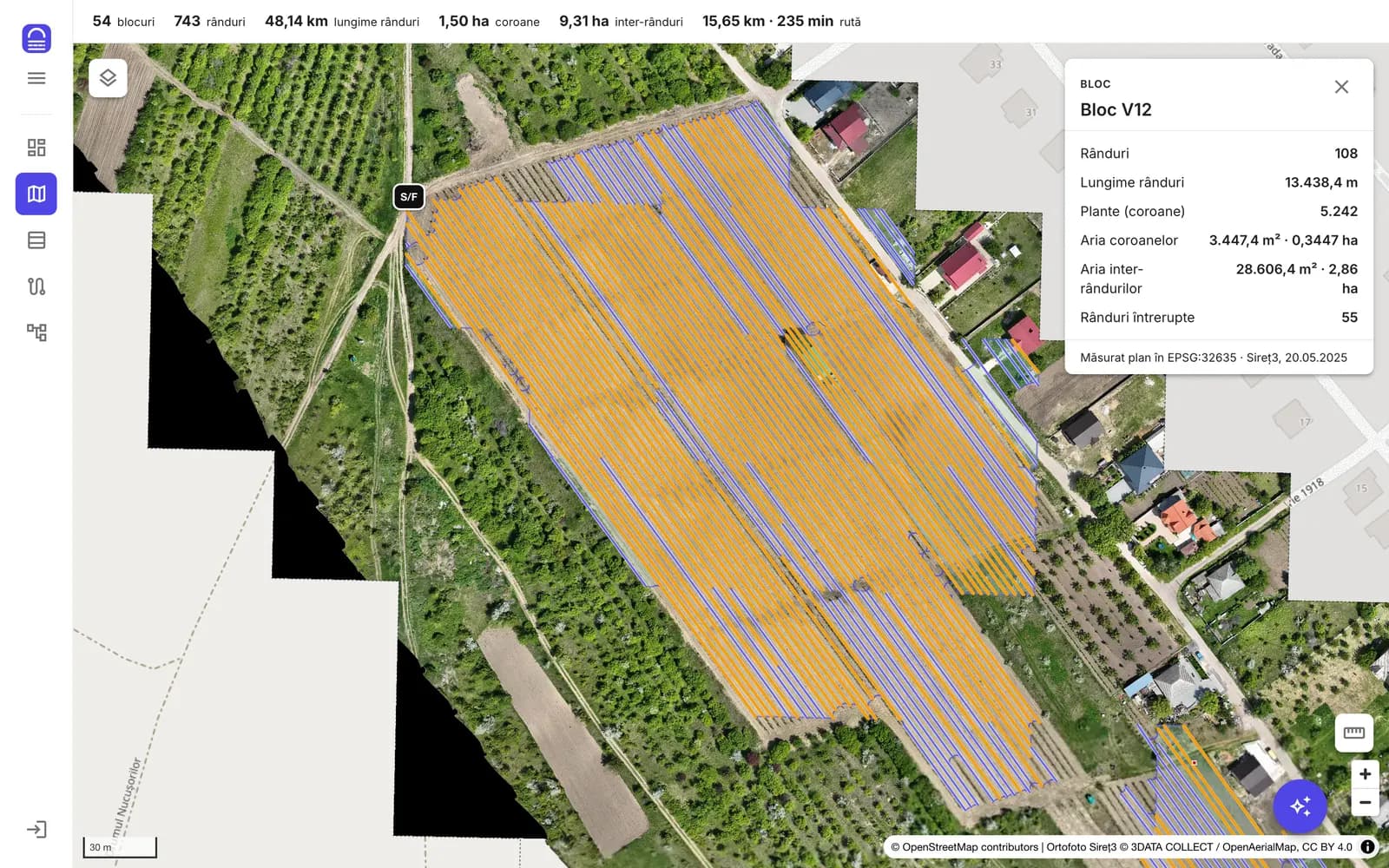
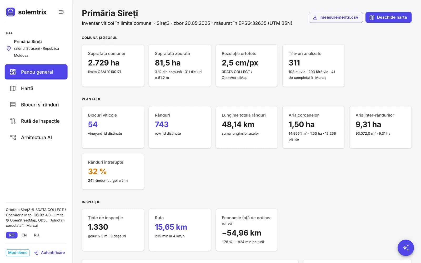
Pilot: Sireți commune, Strășeni district
Flight of 20/05/2025, 311 tiles of 51.2 m, 2.5 cm/px resolution. Figures computed by the platform, measured planimetrically in metres.
81.5
hectares analysed
13,702
plants counted
674
rows measured
47.7
km of rows
149
rows with gaps over 5 m
1,226
inspection targets
25.2
km, the route that visits them
Vineyard data no longer keeps up with the field
Decisions on subsidies, abandoned land and registers rely on self-declarations and on rare, costly manual checks.
45,500 ha vs 66,400 ha
The register and the statistics disagree
The Vine and Wine Register and the National Bureau of Statistics reported wine-grape areas more than 20,000 ha apart (2024). The register relies on self-declarations.
ONVV, NBS, 2024
7 : 1
More is uprooted than planted
For every hectare planted in the last 8 years, seven were uprooted. Records change faster than they can be checked in the field.
ONVV, September 2026
5 districts
Subsidy control without an integrated system
The Land Parcel Identification System (LPIS) was piloted in only five districts. The Court of Accounts points to missing traceability and a risk of double funding.
European Commission 2025, Court of Accounts 2026
2 years
Abandoned land is checked on complaint
Land Code no. 22/2024 lets the municipality lease out land left uncultivated for 2 years, but the finding is made in the field, case by case.
Land Code no. 22/2024, GD no. 688/2024
How it works
From a drone flight to a list of field checks, in four steps.
01
Drone flight
A licensed operator photographs the commune at 2.5 cm/px. The result: an orthophoto where every vine is visible.
02
AI analysis
The model detects blocks, rows, each plant's canopy, inter-rows, gaps and waste. A human operator can correct the annotations before publishing.
03
The municipality's map
Each municipality sees only the area within its administrative boundary: map, indicators per block and row, tables and export.
04
Field tasks
Gaps, missing plants and waste become tasks for inspectors, with a due date, priority, notification and an optimised route (GPX for the phone).
What the institution gets
Map
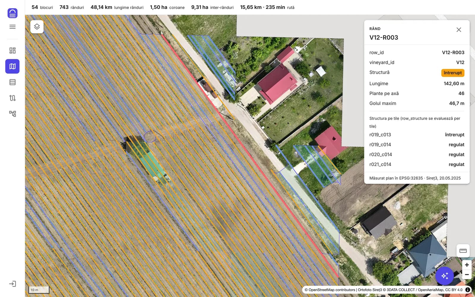
Every row, with length, plants and the largest gap
Click any row or block: length, number of plants, largest gap, canopy and inter-row area. Search by code, measure distances and areas, 3D view.
Tasks and team
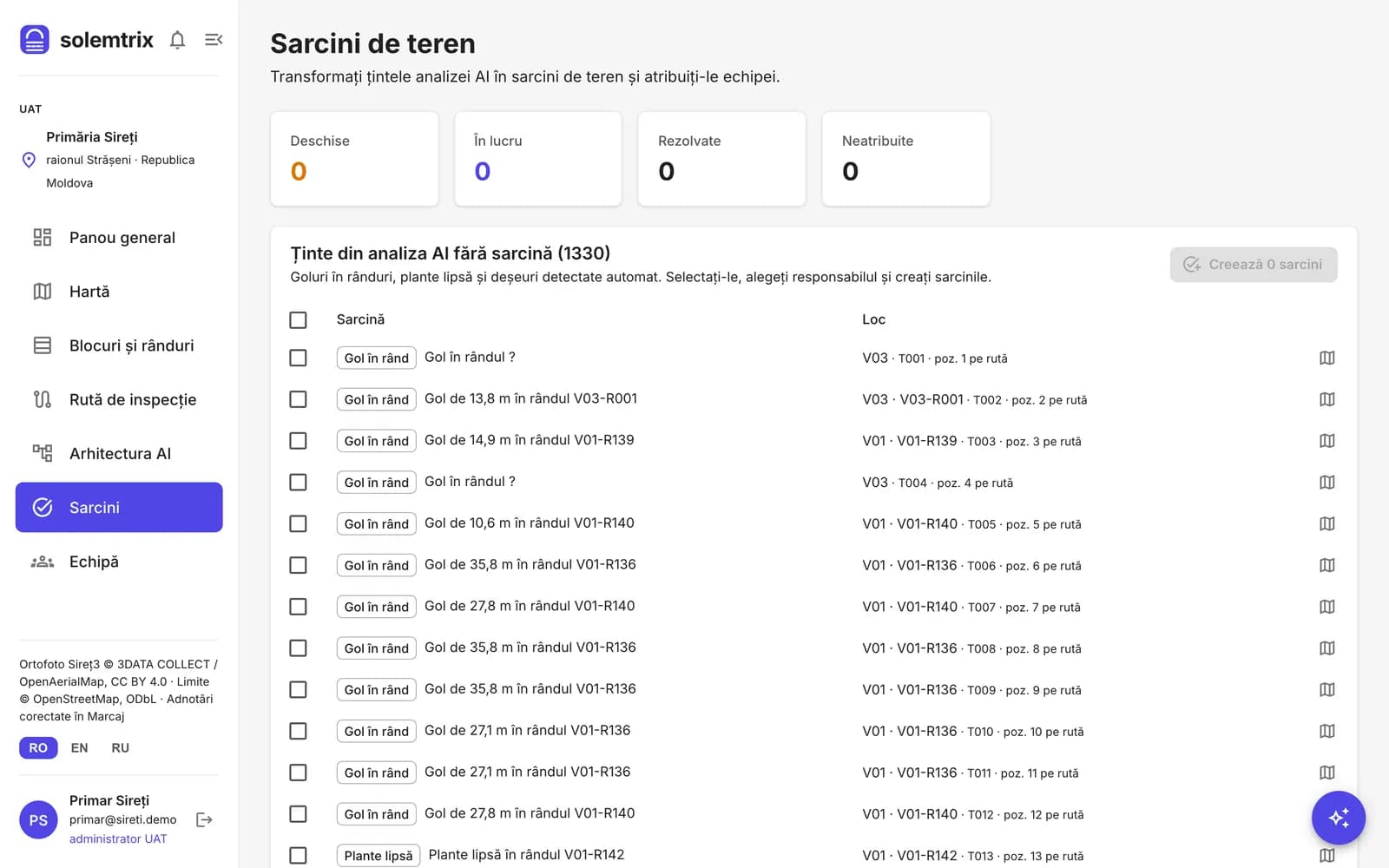
From the AI analysis straight to the inspector's list
The municipality admin picks the targets and assigns them to the team with a due date and priority. The inspector is notified, sees the place on the map and closes the task with a field note.
In the field
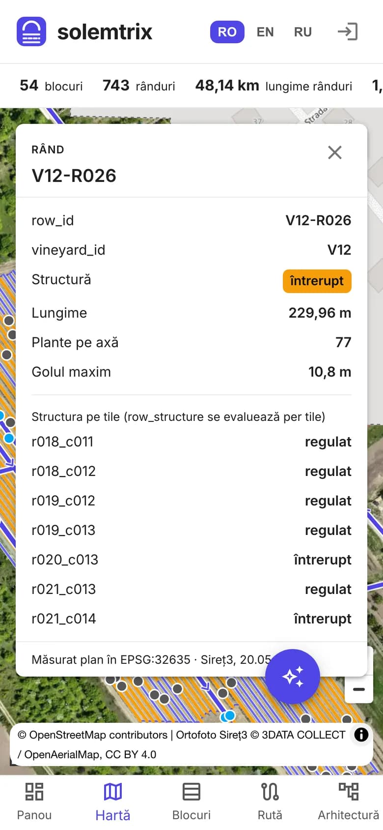
Works on a phone
The map, the tasks and the route open on the inspector's phone. The route exports to GPX for any navigation app.
Reports
Figures ready for a report
The municipality dashboard gathers areas, the number of blocks, rows and plants, disrupted rows and the route. Tables export to CSV in the organisers' format.
Who it's for
The same map answers different questions, depending on who uses it.
Municipalities
mayor, cadastral engineer, agriculture specialist
the commune's vineyard inventory, updated with every flight
evidence for neglected land (Land Code no. 22/2024)
waste and dumps located on the map
data for projects and funding applications
District councils
land relations service, agriculture department
several communes on the same platform
prioritising field checks
comparable indicators across localities
ONVV, AIPA, MAIA
register, subsidies, control
independent check of the areas declared in the Vine and Wine Register
targeted control of subsidised plantations, per plant and per row
a detail layer (2.5 cm) complementing satellite imagery for LPIS/IACS
Security and data
Built for public data, with strict rules on who sees what.
Hosted in the European Union
The database runs in the Ireland data centre. Encryption in transit and at rest is provided by the infrastructure provider.
Each municipality sees only its data
Isolation per municipality is enforced by the database (row-level policies), not only by the interface.
Clear roles
Municipality admin, inspector, viewer. Nobody sets someone else's password: members are invited by email.
Action log
Enrolments, accounts and access changes are recorded in a log that cannot be edited.
The data belongs to the institution
Export at any time in open formats: CSV, GPX, GeoJSON.
In the state language
Interface in Romanian, with English and Russian for mixed teams.
Personal data is processed under Law no. 195/2024 on personal data protection; the terms are agreed in writing with each institution before the pilot.
How we start
No procurement at first: the pilot runs under a cooperation agreement.
- 60–90 days
1. Free pilot
One commune, one flight, the map and tasks for the municipality's team. At the end: a report and a decision.
- yearly
2. Subscription per municipality
Priced by vineyard area, sized for the low-value procurement procedure. Flights are quoted separately.
- district or national
3. Project at scale
For district councils and central agencies: a contract via MTender, possibly co-funded by European programmes.
Frequently asked questions
A drone operator licensed under Government Decision no. 949/2022. We organise the flight together with the municipality; within 10 km of the border the Border Police's approval is also required.
They do not replace the cadastre or property titles. They are working data that show precisely where a field check is worth it and how much area is planted.
They complement each other. Free satellite imagery has 10 m per pixel and shows the parcel; the drone has 2.5 cm per pixel and shows every plant, the gaps in a row and the waste.
A contact person and consent for the flight. We take the commune's administrative boundary from OpenStreetMap, and the municipality admin creates the team's accounts.
In the European Union (Ireland). The data belongs to the institution, which can export it at any time in open formats.
Areas and lengths are computed in metres, planimetrically, from 2.5 cm/px imagery. AI annotations can be checked and corrected by a human operator before publishing, and any row can be checked on the orthophoto.
The pilot requires no procurement. The yearly subscription can be bought through the low-value procurement procedure; large projects through MTender.
Request a pilot for your commune
Leave your contact details and we will reply with the steps for the pilot.